Showing posts with label US Geography. Show all posts

Jan 23, 2016

Jonas Blizzard Buries Northeastern U.S.

    WEATHER ALERT!    
Snow Blizzard Buries Northeastern U.S.


Winter Storm Jonas buries Washington D.C.
Statue of James Garfield with U.S. Capitol Building in the Background.
Photo taken January 23, 2016 by Geoff Alexander via Flickr. CC BY-2.0


If you have watched the Weather Channel at all the past day or two, you should know that the Snow Storm they have named "Jonas" has buried the Northeastern United States. As of Saturday evening (Jan. 23), the Weather Channel is reporting that Washington DC, Baltimore, New York and many other cities in the Northeast have had over 2 feet of snow.


Here are some other photos:


Queens, New York.
Photo taken January 23, 2016 by John Gillespie via Flickr. CC BY-SA-2.0

Howard Street in Baltimore, Maryland.
Photo Taken January 23, 2016 by Seth Sawyers via Flickr. CC BY-2.0.

But after all, weather happens. It’s been happening for thousands and even millions of years, and depending upon the physical geography of where you are, sooner or later you are going to experience some type of severe bad weather. Whether that weather (pun intended) is a brutal blizzard in the Northeast, upper Midwest or Rocky Mountains, a hurricane along the Gulf or Atlantic coast, a tornado in the Great Plains, flooding along the Mississippi River, a heatwave in the South, or a draught in the West leading to devastating forest fires: weather happens. Yes, WEATHER HAPPENS! And so far all we can do about it is try to predict it, be prepared for it, respond to it and basically just deal with it.

When my wife and I were creating the Dr. Toy Award Winning educational board game Snapshots Across America, we wanted to have a fun “gotcha” factor to create interactive competition with players. Since players are “traveling” across a game board map of the United States to visit tourist attractions from all 50 States, we thought what if your “vacation” got ruined by “bad weather”.

So we introduced “bad weather” cards like this one that would cancel another players vacation to any of the States shown on the card.

Snapshots Across America features other different “Weather Alerts” for different regions around the United States that can be played to “spoil” another player’s vacation to one of the States affected by that bad weather. 

But one of the real benefits of this aspect in our game is it also gives families an opportunity to start talking with their children about what happens if you face or have to experience bad weather. What types of potential bad weather happen in your area? How do you protect yourself in a storm? Do you have an emergency plan? Do you have backup power, heat or water? Do you have an emergency kit with flashlights, food, water and other necessities that might be needed?

A good source of information for what you may need in an the event of an emergency or severe weather is:


Jan 22, 2016

Need A Vacation? Save 20%

SAVE 20% on
Snapshots Across America
now thru 2/7/16

At Checkout use discount code:

Homeschool


Snapshots Across America is the Dr. Toy Award Winning Game where players learn U.S. Geography while "travelling" across a game-board map of the United States to "visit" actual places from all across America.
Great for helping families learn U.S. Geography as well as about many great Landmarks, National Parks, Museums, National Monuments, Memorials, Historical Sites, and many other fun and educational attractions all across America.


Dec 7, 2015

Snapshots Spotlight-Remembering Pearl Harbor


Remembering the Attack on Pearl Harbor
and the USS Arizona.


It started out as a quiet Sunday in Paradise, exactly 74 years ago today. On December 7, 1941.
The Naval Base at Pearl Harbor as it looked prior to the attack on December 7, 1941.
(Photo by US Navy on October 13, 1941, less than 2 months before the attack)

The Japanese Empire had made several successful conquests on the Eastern half of the Pacific. They viewed the United States as their primary obstacle to dominating the entire Pacific Ocean region. The Japanese fleet, including 6 aircraft carriers loaded with around 450 aircraft, departed Japan on November 26, 1941. Radar from an American Army outpost had detected a large aerial formation shortly before the attack, but it was disregarded as they thought it was incoming flight of friendly planes from the mainland that they were expecting that day.

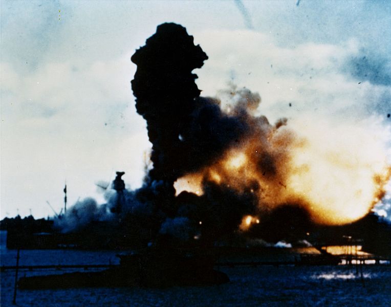
The forward  weapons magazine on the USS Arizona explode shortly after 8:00 am after being hit.
(Official U.S. Navy Photo)

The first wave of Japanese places attacked at 7:55 am, local time, and caught the U.S. Pacific Fleet stationed at Pearl Harbor completely by surprise. The enemy attack concentrated on “Battleship Row” and the six airfields nearby. Eight U.S. Battleships were put out of commission. 2,335 U.S. soldiers and 68 civilians lost their life in that attack

The USS Arizona sinking after being hit.
(Source U.S. National Archives and Records Administrationfrom the Franklin D. Roosevelt Library)

The USS Arizona suffered the worst damage of the entire fleet when its artillery magazine was hit, causing a chain reaction of explosions on the ship. 1,104 servicemen aboard it lost their lives in that attack, accounting for almost half of all the casualties from that day.

An aerial view of the USS Arizona Memorial straddling the sunken hull of the Battleship that sank in the Attack on Pearl Harbor.
(US Navy Photo by  Jayme Pastoric Cropped from original)

The USS Arizona Memorial is one of the most visited National Historical Sites in the United States. The next day, President Franklin Delano Roosevelt addressed Congress and the Nation. "Yesterday, December 7th, 1941 -- a date which will live in infamy -- the United States of America was suddenly and deliberately attacked by naval and air forces of the Empire of Japan."

In these troubling times, let us always remember the resolve and commitment that the generations who have gone before have done to protect our Great Nation and the Freedoms we have.


The USS Arizona Memorial, in Pearl Harbor, Hawaii, is one of the popular attractions featured in the latest edition of Snapshots Across America.

For more information on Pearl Harbor visit:


National Parks Teaching With Historic Places Lesson Plans


www.SnapshotsUSAgame.com

Feb 21, 2015

Snapshots Spotlight: Blizzard buries New England

Piled up snow along the street and sidewalk in the Boston, Massachusetts area
after yet another snow storm hits New England. 
February 15, 2015.
Source: 
Peter Enyeart, Flickr. CC-BY-2.0.

Snapshots Spotlight:
Blizzard Buries New England

Another week goes by and New England gets dumped on by another big snow storm. According to the Weather Channel website, as of February 18, Boston has had 98.7 inches of snow so far this Winter. That’s over double the average annual snowfall of 43.5. February 2015 is already the snowiest month ever in Boston at 61.5 inches of snow, and it still isn’t over yet. That’s compared to 2nd place January 2005 with 43.3 inches.

So why has this year been so snowy in New England? Hmmmmm. My “theory” is that Mother Nature is punishing New England for the Patriot's football #DeflateGate, with its own version of a “low pressure system”.  
;>P

Along those lines, I like the editorial cartoon that appeared a few weeks ago in the Boston Globe by Dan Wasserman:


Source: Dan Wasserman, Boston Globe

But after all, weather happens. It’s been happening for thousands or even millions of years, and depending upon the physical geography of where you are, sooner or later you are going to experience some type of severe bad weather. Whether that weather (pun intended) is a brutal blizzard in New England, upper Midwest or Rocky Mountains, a hurricane along the Gulf or Atlantic coast, a tornado in the Great Plains, flooding along the Mississippi River, a heatwave in the South, or a draught in the West leading to devastating forest fires: weather happens. Yes, WEATHER HAPPENS! And so far all we can do about it is try to predict it, be prepared for it, respond to it and basically just deal with it.

So here is an opportunity for you to think about what types of severe weather can affect where you and your family live. Blizzards? Polar Vortex? Tornadoes? Hurricanes? Floods? Etc.? What can you do to be better prepared for when severe storms hits?

When my wife and I were creating the educational board game Snapshots Across America, we wanted to have a “gotcha” factor to create interactive competition with players. Since players are “traveling” across a game board map of the United States to visit tourist attractions from all 50 States, we thought what if your “vacation” got ruined by “bad weather”.

So we introduced “bad weather” cards like this one that would cancel another players vacation to any of the States shown on the card.

Snapshots Across America features other different “Weather Alerts” for different regions around the United States that can be played to “spoil” another player’s vacation to one of the States affected by that bad weather. According to some of our reviews, players like being able to “spoil” a sibling’s, parent’s or friend’s “vacation” by hitting them with bad weather. 


But one of the real benefits of this aspect in our game is it also gives families an opportunity to start talking about what happens if you experience bad weather. How do you protect yourself in the storm? Do you have an emergency plan? Do you have backup power, heat or water? Do you have an emergency kit with flashlights, food, water and other necessities that might be needed?

A good source of information for what you may need in an the event of an emergency or severe weather is:
 http://www.ready.gov/build-a-kit

For more information about Snapshots Across America, and the new updated edition to be release this coming Summer 2015, follow our blog or like us on Facebook


Copyright 2015, Sandell Games.

Feb 6, 2015

Snapshots Spotlights: US National Parks

Visitors observing the magnificent grandeur of the Grand Canyon National Park from
Mather Point on the South Rim. National Park Service Photo by Michael Quinn

Snapshots Spotlight 

US National Parks: An American Treasure


In the 2009 PBS documentary series, The National Parks: America’s Best Idea, Dayton Duncan and Ken Burns eloquently describe our National Parks: “They are a treasure house of nature’s superlatives---84 million acres of some of the most stunning landscapes anyone has ever seen…. But they are more than a collection of rocks and trees and inspirational scenes from nature…. [They are] where countless American families have forged an intimate connection with their land—and then passed it on to their children”.1

The first concept for setting aside large preservations of land of natural and cultural beauty is attributed to American painter and writer, George Catlin. During the 1830’s, Catlin travelled extensively through much of North America on an endeavor to capture the images on canvas of North American Indians and the wilderness they lived in. In 1842 Catlin published writings chronicling his adventures and suggested that the government should preserve what he called “a Nations Park” that would preserve and showcase the “pristine beauty and wildness… where the world could see for ages to come”.2,3

Yosemite National Park. The view of El Capitan on the left, Bridal Viel Falls to the right and Half Dome in the distant center.
Photo by DAVID ILIFF. License: CC-BY-SA 3.0
.

     As other travelers, painters and writers explored and witnessed the spectacular scenery of the expanding United States, the interest in preserving the majestic natural beauty of those areas grew. The first such area was Yosemite Valley, which in 1864, California Senator John Conness sponsored legislation which was signed by President Abraham Lincoln. That set aside Yosemite Valley as a protected land and under the control of the State of California, would become America’s first designated State Park. Later the Yosemite Valley would become part of the larger Yosemite National Park.2


Old Faithful Geyser, one of the most popular attractions in Yellowstone National Park,dwarfs visitors watching from nearby. National Park Service photo by Jim Peaco

The very first official National Park established in the United States, as well as the World, was Yellowstone National Park. During 1869-71, several expeditions ventured into the remote area of the territories of Wyoming and Montana. David E Folsom, Henry D. Washburn and Ferdinand V. Hayden had each explored the Yellowstone area and publicized their amazing geologic documentation of the many geysers, as well as other geothermic and geologic features present in the area. However since the proposed park was in a US territory rather than a state like Yosemite in California, it was established as a National Park under the protection and administration of US Federal Government. The bill passed Congress in 1872 and was signed into law by President Ulysses S. Grant.2

In 1875, Mackinac Island, located on Lake Huron in the state of Michigan, was designated as the second US National Park. However in 1895, it was transferred to the State of Michigan and become a State Park. In 1890, three National Parks were established in California: Yosemite, Sequoia and General Grant (which later became part of Kings Canyon National Park in 1940).2

Between 1899 and 1919, many other National Parks were established:
  • Mount Rainier National Park, Washington, 1899
  • Crater Lake National Park, Oregon, 1902
  • Wind Cave National Park, South Dakota, 1903
  • Mesa Verde National Park, Colorado, 1906
  • Glacier National Park, Montana, 1910
  • Rocky Mountain National Park, Colorado, 1915
  • Hawaii National Park, 1916, (Later split into Hawaii Volcanoes and Haleakala in 1960)
  • Lassen Volcanic National Park, California, 1916
  • Mount McKinley National Park, Alaska, 1917 (Later became Denali National Park in 1980)
  • Grand Canyon National Park, Arizona, 1919
  • Zion National Park, Utah, 1919.


President Theodore Roosevelt and conservationalist John Muir during a tour of
Yosemite National Park in 1903.
Photo from The National Parks: Shaping the SystemNational Park Service.

One of the greatest advocates for the establishment of Protected National Parks was conservationist and a founder of the Sierra Club, John Muir. Muir first travelled to the Yosemite Valley in 1869 to take a job working in a sawmill. However, his life was forever transformed by the natural beauty and grandeur he witnessed there. He has been described as the “patriarch for both the idea of wilderness preservation and the development of National Parks”.4

John Muir became instrumental in aiding the preservation of land for seven National Parks. In 1903 he gave President Theodore Roosevelt a tour of Yosemite National Park to see many of the magnificent views of the scenery there. President Roosevelt, after experiencing Yosemite and several other National Parks that year, would become one of the greatest political advocates and a primary supporter of  the National Parks, signing legislation that established five additional National Parks, and designated 18 National Monuments during his presidency.1


“Thousands of tired, nerve-shaken, over-civilized people
are beginning to find out 
that going to the mountains
is going home; that wildness is a necessity;
and that mountain parks and reservations are useful,
not only as fountains of timber and irrigating rivers,
but as fountains of life.”
 John Muir4                 


      The National Park System has grown significantly since it was first established. Currently there are 59 US National Parks that are a beautiful treasure of diverse gems scattered across 27 states and two US Territories. California has the most of any state with nine, Alaska is next with eight, Utah has five and Colorado with four.5

So why go visit a National Park? Sometimes just witnessing the immense beauty of nature can offer a great peace, strength and clear perspectives in life. Great people with an appreciation for some of the most awe inspiring places have gone before us to preserve these remarkable works of nature for us to see, value and appreciate. Experiencing and witnessing those magnificent National Parks, will give us the courage, the strength and the determination to continue to support, preserve and pass on those majesties of nature to the many future generations to come. So help support and preserve an American Treasure! Visit a National Park!

Snapshots Across America features these game cards:


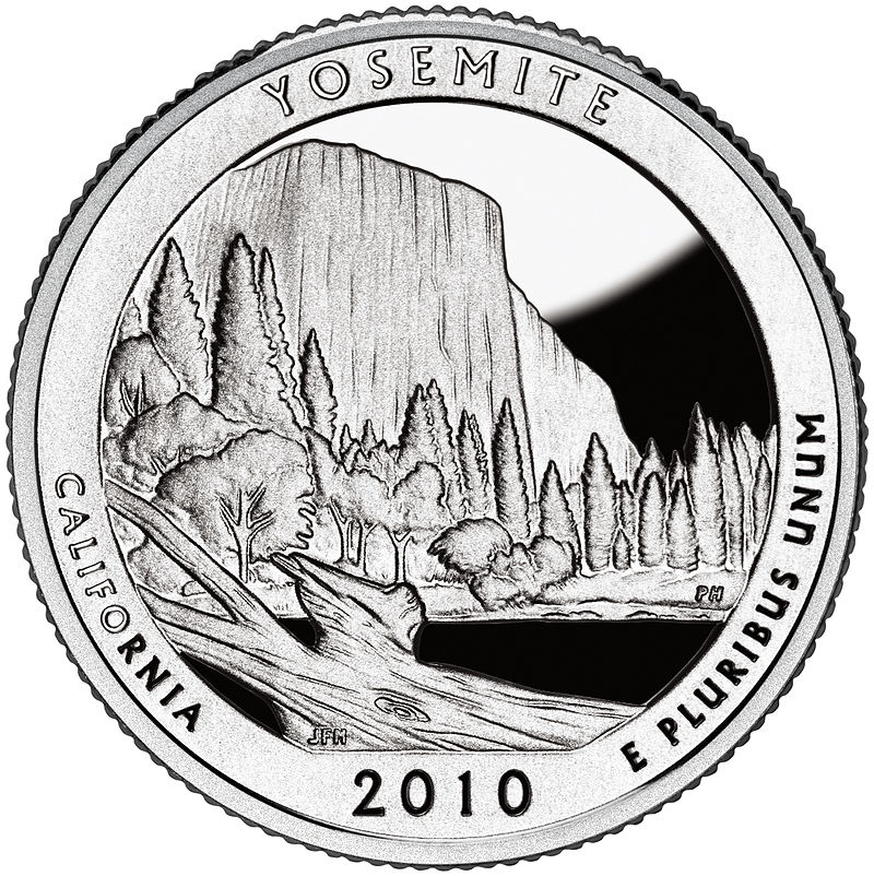
Yosemite, Yellowstone, and the Grand Canyon National Parks have also been featured on the new U.S. Mint America the Beautiful Quarters that were released in 2010.

Follow us for more Snapshots Spotlights about the many great tourist attractions 
featured in the educational boardgame, Snapshots Across America. New edition to be released Summer 2015.


Sources:
1Dayton Duncan & Ken Burns. The National Parks: America’s Best Idea. PBS Documentary Series aired 2009. Companion Guide. Alfred A. Knopf. New York. Print. 2009.

2Barry Mackintosh. The National Parks: Shaping the System. National Park Service-U.S. Department of the Interior. Washington, D.C. Print. 1991. Web.

3George Catlin. Letters and Notes on the Manners, Customs and Conditions of the North American Indians. Wiley and Putnam. New York. Print. 1842. Web.

4John Muir. Our National Parks. Houghton Mifflin and company. Boston-New York. Print. 1901. Web-Library of Congress.


5The official Website of the National Park Service. http://www.nps.gov/index.htm.
US Department of the Interior. Washington D.C. Web.


Copyright 2015, Sandell Games.

Jan 27, 2015

Welcome to the New Snapshots Across America Blog.


A brief history of Snapshots Across America, the Vacation Destination Board Game.


Snapshots was first created and published in 1997, in Jackson, Michigan. It was originally test marketed and sold in approximately 10 stores in 3 different states.

In 1998 it was licensed to Tedco, Inc., an educational toy manufacturer located in Hagerstown, Indiana.

Tedco, Inc. introduced Snapshots in February 1999 at the International Toy Fair in New York.

Also in 1999 Snapshots won 2 Dr. Toy Awards for 10 Best Games, and 100 Best Children's Products.

In 2001 Talicor, Inc. took over manufacturing and distribution of the 3rd edition which has become a popular educational United States Geography game.

In 2004, Snapshots Across America was featured in an article in the Reader's Digest on educational games for Children.

We appreciate all of our fans, especially those who recommend and use our game in the educational field, and homeschooling.

We are proud to announce the new edition of Snapshots Across America to be released in the Fall of 2015. This will be the fourth edition of Snapshots and will have many improved features including:


  • An expanded deck with more Attraction Cards than before.
  • Larger sized cards with larger sized photos than previous editions.
  • Expanded educational information about popular Attractions.
  • More transportation cards than before
  • More Bad Weather Cards and transportation cancel cards than before.
  • Improved and updated instructions and rules.
  • New expansion decks to be released starting in the Fall of 2015 to add even more popular attractions than those in the standard deck.
For more updated information, follow our blog or like us on Facebook